© Wayne Watson

© Wayne Watson

© Wayne Watson

© Wayne Watson

© Wayne Watson

© Wayne Watson

© Wayne Watson

© Wayne Watson

© Wayne Watson

© Wayne Watson


Retour de l’est brings huge dumps of snow to Val d'Isere
Another wild week, but with more snow on the forecast
We had just about everything this week with snow, wind, and some well-timed sunshine, and it’s been another brilliant week of skiing. For the first time this season we’ve had a proper retour de l’est, which dumps huge amounts of snow at the Fornet while keeping the sector under cloud cover for the most part.
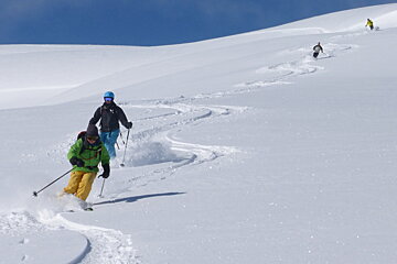
This means the off-piste skiing is more dangerous the closer you get to the border plus openings can be delayed due to the massive amount of snow that needs to be dealt with. With that in mind we headed to Tignes where we enjoyed some sunshine along with 30 to 50 cm’s of fresh snow, and the skiing was fantastic! (See photos)
On Monday we had some wonderful snow in the Campanules and off the Grande Motte and with clear skies until around noon it was a real bonus. On Tuesday I headed towards Tignes via a fantastic run on the Borsat Nord and skied a lovely run off the Grande Motte, but returned to Val d’Isere due to crowds. We then had an atmospheric run on the impressive Face du Charvet before skiing trees off the Mattis.
On Wednesday it was back to flat-light and we skied into Tignes via the Little Lavachet, followed by a run down the Sachette Couloir into Les Brevieres. On Wednesday afternoon the wind started to blow and we experienced a pretty ferocious storm that continued all-day Thursday. Winds of 150km/h were recorded on the Fornet Glacier and with -14C on the top of Bellevarde with a strong gusting northerly wind Thursday morning any exposed skin was frostbitten pretty quickly. It wasn’t a day for the faint-hearted but for those who persevered there was some pretty good skiing to be had, and queuing certainly wasn’t a problem! (In fact, after about 11 o’clock most of the keen people who started the day had headed home for shelter and it was pretty lonely out there!)
Tuesday was a huge bonus as the threatened Pisteurs Strike that could have shut the mountain down was avoided with some last-minute negotiations. It was a sunny day with fantastic snow and it would have been a real shame to have missed it. I’m not too sure if the Pisteurs demands were met or not or what type of compromise was agreed, but everyone was grateful that the strike was called off.
With all the fresh snow it was another tough week for piste skiers. The piste service does a fantastic job preparing the pistes but they just don’t hold up with the soft snow and extensive holiday traffic. It has been one of the busiest weeks of the season and with limited openings some days due to snow and wind the open pistes have been very crowded.
After the storm blows itself out Thursday night the wind will turn from the NW to SW.
- Friday- Partially sunny AM-Cloudy PM and snow -11C/+1C Wind from the SW at 10km/h
- Saturday- Snow -7C/-2C Wind from the S at 5km/h
- Sunday-Partially sunny and snow -10C/-4C Wind from the S at 5km/h
- Monday-Partially sunny -10C/-3C Wind from the NW at 5km/h
The cold temperatures are fantastic for the quality of the snow but beware of the wind-chill factor at altitude. Listen in to Radio Val in the mornings as they’ll give you resort temperatures, temperatures at altitude and the wind strength on the summits. You don’t want to be ambushed and not having the appropriate clothing.
It should be another brilliant week coming up as this most wonderful winter continues. Have a great weekend and stay tuned for another update on Monday!
-
For more updates on a daily basis, follow Wayne's blog.